Interactive Maps of Nevada City and other Neighborhoods
A picture tells a thousand words, but a map can actually help take you there! Each of the links below will take you to an interactive map of the area.Finding Mining Ditches for Yourself
Explore around anywhere in western Nevada County and take a look at your neighborhood.
You can switch to see the lidar "Slope" layer (under Show Layers) to discover old hydraulic mining claims, hidden mine shafts and ditches.
Unveil the nearly 2,000 recorded mines in the area. Turn on the Ditch Legend (under Show Layers) to what all the ditches are called or click on one to find out more information.
See all the different public trails, parks, property boundaries, the official Nevada County map, contours, terrain,
9 different aerial views, topological maps, public land, historical map overlays, modern canals, water diversions, and much more.
Below there are another 50+ featured descriptive maps with more information about specific areas.
Check out the points of interest  or ones with a photo
Nevada City
Willow Valley
Gold Flat
Lower Banner
Deer Creek
Rock Creek
Newtown
Blue Tent
Cascade Shores
Alpha
Omega
Washington
Grass Valley
Rough and Ready
See How Lidar Technology Uncovers our History
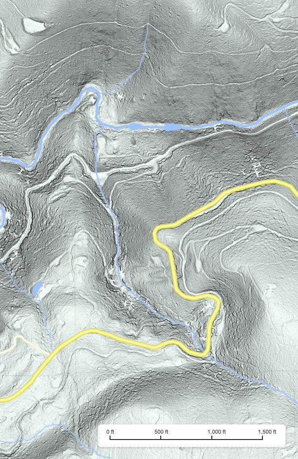
 The left image is a lidar-rendered "Slope" image showing the white outlines of ditches and old roads in Willow Valley, just below Deer Creek Reservoir.
The two Snow Mountain ditches are quite prominent north of Deer Creek.
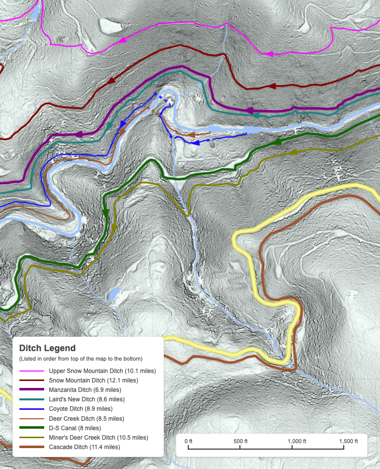
The right image add the ditches drawn in. The D-S Canal and Cascade Ditch are most prominent to the south of Deer Creek, on either side of Pasquale Road (in yellow).
The left image is a lidar-rendered "Slope" image showing the white outlines of ditches and old roads in Willow Valley, just below Deer Creek Reservoir.
The two Snow Mountain ditches are quite prominent north of Deer Creek.
The right image add the ditches drawn in. The D-S Canal and Cascade Ditch are most prominent to the south of Deer Creek, on either side of Pasquale Road (in yellow).
More Than 50 Local Maps to Discover
Gold Rush Nevada City - If you are not familiar with the town or the area, check out this Nevada City Area Map to yourself get oriented. The Cayote Range was the area just north of Nevada City, now close to highway 49, which was rich with gold in the early days of the Gold Rush. After many city-wide fires, including the great fire of July 1856 and the May 1858 fire, the city finally voted on competing fire protection proposals in June 1860. This lead to the creation of Marsh's Pond, the city's first reservoir, by the Madelyn Helling Library, north of town.
You can also check out an early street map of Nevada City from 1869. And from around the same time the original USGS land survey was carried out between 1867-1872. Later in the early 1890s, the USGS created the first accurate topological maps of the area, covering Nevada City and Banner Mountain and Grass Valley.
The Early Ditches - The Mosquito Ditch provided the first water to the miners on Coyote Hill, northeast of Nevada City. The Rock Creek Ditch brought water to Sugar Loaf Mountain and was the first commercial ditch that cost $10,000 to build and paid for itself in the first 6 weeks of operations. The Coyote and Deer Creek ditches were competing water companies that brought year-round water from Deer Creek to the mining claims on Coyote Hill and Coyoteville, northwest of Nevada City.
Rough and Ready - The original Rough and Ready and Slate Creek ditches started in Nevada City on Deer Creek, but flowed all the way Randolph Hill and Rough and Ready.
Willow Valley - Ten different ditches flow through Willow Valley, east of Nevada City, from Willow Valley Creek (formerly Laird or Slate Creek) and Deer Creek, west to Nevada City. This included Tomlinson's Ditch, originally dug by Amos Laird and John Wadsworth in the spring of 1851.
Gold Flat - To the southeast of Nevada City, Gold Run Creek flows across Gold Flat. The rich mining claims there in the 1850s need water from Little Deer Creek and Deer Creek to allow the miners to recover all the gold. Several ditches including the Miner's Deer Creek Ditch, Laird's Gold Flat Ditch, Union Ditch were built to support this busy mining district. Later in 1874, John Dunn, Charles Marsh, and the Cooper brothers built a 14-mile-long V Flume to bring immense amounts of timber and lumber to Town Talk, at the gap between Gold Flat and Brunswick Basin.
The Snow Mountain Ditches - Justus Fordyce and Dan Rich started a new set of ditches on April 7, 1853. The first, the Fordyce and Rich Rock Creek Ditch, was brought water from Rock Creek to Sugar Loaf Mountain. In 1854, they started the Snow Mountain Ditch and Little or Upper Snow Mountain Ditch. Today, the Snow Mountain Ditch still brings water from Deer Creek to residents in the Cement Hill area.
In February 1855, the dominate water company, the Rock Creek, Deer Creek and South Yuba Canal Company started work on the immense South Yuba Canal, from the South Yuba River to the south fork of Deer Creek. It would take three years and about $600,000 to complete.
Laird's Lost Hill Diggings and his New Ditch - Amos Laird, for a time, was the richest miner in Nevada City. His mining claims on Lost Hill, American Hill and Wet Hill, all northwest of Nevada City were some of the most profitable in the city. But they needed huge amounts of water to keep them running. Laird built his New Ditch with an enormous wooden dam at Scotts Flat. In February 1857, the dam broke flooding parts of Nevada City, washing away several buildings and two bridges.
The Mountain Lakes and Ditch Network on Washington Ridge - The South Yuba Canal Company constructed a large number of reservoirs and mountain lakes to store water for the summer months. Water was then channeled down the South Yuba Canal and into the Ridge Ditch. They also build branch ditches to Alpha, Gold Hill, Omega and Blue Tent. Later the Blue Tent Mining Company built another immense ditch to their Blue Tent mining claims.
Quaker Hill and Cascade Shores - Amos Laird built the original Cascade Ditch from Deer Creek to provide water to Sargent & Jacobs mining claims on Quaker Hill and others tothe south in Hunt's Hill.
Cement Hill and Hirschman's Pond - There were several ditches that provides water to the mining claims on Cement Hill, northwest of Nevada City during the 1870s. The famous Hirschman Diggings were later consolidated into the later Hirschman & Grover in the 1880s and early 1900s. Manzanita Diggings - Near the site of the earlier Coyote Hill, the Maltman brothers grew their early mining claims to cover most of Sugar Loaf Mountain to create today's immense Manzanita Diggings. In 1880, a new Manzanita company built the large Manzanita Ditch to power the mine and wash the pay dirt.
In 1873, the Idaho Mine was the first to switch to water power, constructing the 12-mile-long Idaho Ditch, from Scotts Flat and supplied by the Snow Mountain Ditch. In November 1882, the New Cascade Ditch took over supplying water to the quartz gold mines, which drove Pelton Wheels to power the mills, hoists and water pumps. The modern Cascade Canal has replaced most of the old ditch with a pipeline.
Harmony Ridge and Lake Vera - To the north of Nevada City, the mines of Harmony Ridge (based on this old map) needed a new ditch in 1891 for water power. Some of the first electricty was generated from the South Yuba River and with the creation of the Lake Vera and the China Dam Ditch.
Nevada Irrigation District - In 1921, NID was formed to provide water to much of western Nevada County. It slowly acquired many of the old ditches, constructing the D-S Canal to create the vast canal network that still operatews today.
About the Ditch Maps - These maps trace the paths of over 200 distinct ditches. You can learn more about their history here. They are based on more than 12,000 GPS reference points taken in the field over the last 5-6 years. The mapped ditches include nearly 100,000 hand-drawn points to trace the 790 miles of all the old ditches. All of the creek and reservoir data was also hand-drawn.
Acknowledgements - The interactive maps on this site uses the Google Maps platform. The terrain, slope and contour data was rendered from the USGS Northern California Lidar Wildfires dataset from 2018, available from the National Map website. The data was then processed using homegrown python scripts leveraging the WhiteboxTools created by Dr. John Lindsay at the University of Guelph in Ontario, Canada. All the road, property boundary, park and trail data was created by the Nevada County GIS team and is available on their website. Current NID canal data comes from safeditches.com. Water diversion data comes from the California State Water Resources Control Board. The locations of nearly 2,000 local area historical mining sites are from the invaluable Western Mining History website, combined with less accurate data from the archaic Bureau of Land Management website.