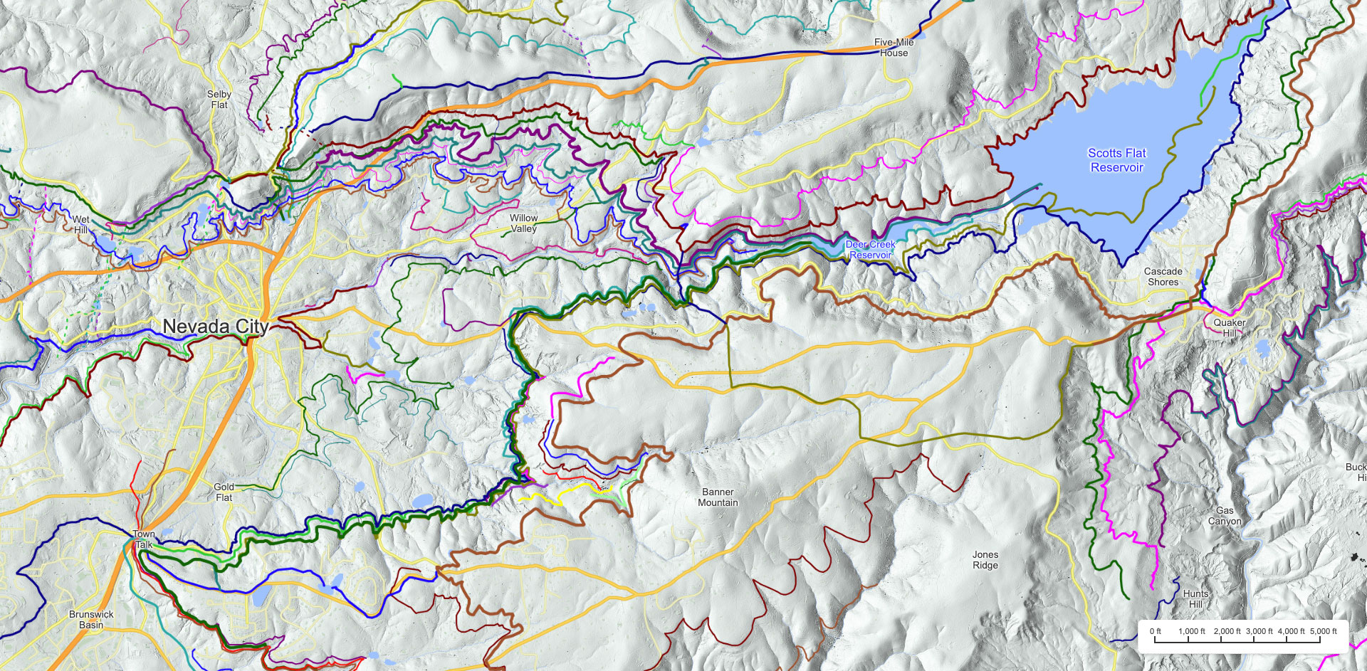
Mining Ditches of Nevada City
Although they are mostly unseen, the remains of an immense number of old mining ditches can be found in and around Nevada City. There are 120 individual ditches within 3 miles of Nevada City alone. These extend a total of over 350 miles up the ravines and valleys to get to their water sources. This site and its accompanying book, The Ditches of Nevada City, maps out and tells the story of over 800 miles of these ditches. And this does not include another 460 miles of modern irrigation canals managed by the Nevada Irrigation District (NID). Below is a map of some of these ditches east of Nevada City in Gold Flat, Willow Valley and Scotts Flat. A complete set of interactive maps can been found here.
The importance of water to early gold miners was summarized eloquently by Aaron Sargent, newspaper editor and later U.S. senator, in his Sketch of Nevada County from Brown & Dallison's Nevada, Grass Valley and Rough and Ready Directory, published in 1856.
He went on to summarize some of the key early ditches that provided the gold miners with the all important water:One of the most important agents in developing the resources of the county has been the water introduced from natural streams by means of ditches. During a large part of the year the business of the region must utterly fail were it not for these artificial streams, that compensate in a great measure for the drought of the summer season, and enable the miner to pursue his calling. The ditching operations have been generally so profitable to the projectors, and so indispensable to the mining interests that they now net nearly the whole county. Wherever good diggings are opened, some enterprising men cast about for a supply of water, and spare no labor to conquer the many obstacles which are presented by a rough, thinly settled country.
In March, 1850, the first enterprise of this kind was undertaken, but upon a small scale. It brought water from Mosquito Creek, a distance of a mile and a half, to Old Cayote Hill. Another ditch in May, 1850, took water from Little Deer Creek to Phelp's Hill, a short distance.
The first enterprise of this kind upon a large scale was unsuccessful. It was started in August, 1850, by a man named Moore, and was designed to take water from Deer Creek, just above Nevada, to Rough and Ready. Moore dug but one mile of his ditch, and was generally accounted crazy for his pains. But the enterprise was taken up in the following January, by Messrs. A. L. and B. O. Williams, who succeeded in getting the water through in the following April, a distance of thirteen miles, and made a great deal of money in working diggings on Randolph Flat with the water.
In September, 1850, Messrs. John and Thomas Dunn, C. Carrol [sic, Carroll] and C.[Charles] Marsh projected the Rock Creek Ditch, taking water from Rock Creek to Nevada, a distance of nine miles, and got the water on to the Cayote Hills in December of the same year. This was the first large ditch in successful operation in the County, and produced great results. Before that time the pay dirt taken from the Cayote lead had all to be hauled in carts to Deer Creek, at the foot of the town, at great expense; and piles of dirt had been left near the shafts on the hills, as useless, because it would not pay to be hauled for washing. These piles of dirt now became valuable, as the water flowed by them, and thousands of dollars were washed out of them. Many persons made their "piles” by “ jumping ” the piles of dirt that had been left as useless, the owners in many cases having gone to the other States well laden with the first produce of the lead. Cayote Claims that before could not be worked to advantage, also became valuable; sluice washing gradually came into use, and the water flowing from the hills where it was first used, down into the ravines, gave opportunity for work where before it could only be done in winter.
In November, 1850, two rival companies began to construct ditches to convey the water of Deer Creek to Nevada. The “Deer Creek Water Co.” began their ditch at the upper end, at the Creek; the “Cayote Water Co.” began at the end next the town. After the completion of the ditches, the companies were involved in continual law suits as to the priority of rights, to avoid which they consolidated in the fall of 1851.
In March, 1851, Messrs. Thomas & Co. started the “Deer Creek Mining Co.'s” ditch, leading from Deer Creek to Gold Flat, fifteen miles in length, and completed it in one year.
The “Newtown Ditch” was constructed in 1851, by Messrs. Dickenson, Newton and others, taking the water from Deer Creek and conveying it five miles to Newtown.
In 1853, Messrs. Spencer, Rich and Fordyce commenced a ditch [the Snow Mountain Ditch] from Deer Creek to Nevada, a distance of twenty miles, which was completed in 1854.
The “Rock Creek, Deer Creek and South Yuba Water Co.," a company formed by the consolidation of all the early Nevada Water Companies, are now [in 1856] constructing a ditch [the South Yuba Canal] from the South Yuba to the head of Deer Creek, and to Alpha and Omega - the most stupendous ditch operation in the State. They have blasted through a bluff of solid granite for over a mile, on the South Yuba, the cliff in some places being eighty feet in height, and the shelf formed fifteen feet in width. They are also cutting a tunnel through the Deer Creek and Steep Hollow ridge, 3,100 feet in length, 204 feet from the summit.
Long after the California Gold Rush was over, ditch construction continued throughout the 1850s and 1860s. To provide enough water for the every thirsty hydraulic mining claims, new even larger ditches were built in the 1870s. And in the 1880s, new ditches were dug to bring water to power the hard-rock mines searching for gold found in quartz-ore.
Click to see a complete list of the featured ditches.
All of these ditches are described in detail in the book, The Ditches of Nevada City.
Click to find an old mining ditch in your own backyard.