The Early History of Nevada City
The earliest days in Nevada City were recorded in a just couple of books at the time and in letters and diaries written by the early prospectors.
In 1856, Aaron Sargent, editor of the Nevada Journal and later US senator, wrote a Sketch of Nevada County
for a new business directory published by Nathan Brown and John Dallison.
He recalled the first gold seekers in September 1849 exploring Gold Run Creek, which today would be next to the South Pine Street bridge. That fall, Dr. A. B. Caldwell build a store in a log cabin, which is now just above the parking lot at the bottom of Nevada Street. As he had another store downstream, the new mining camp was known as “Caldwell's Upper Store” or Deer Creek Dry Diggings. The first family arrived in October. Charley Stamp, his wife Matilda and several children built a cabin, which now would be on Coyote Street just above the Washington Street bridge. The first real wooden building was at the top of Broad Street, behind what is now Bonanza Market on Bridge St.
Sargent also wrote of the many city fires that plagued the town and about the early beginnings of Grass Valley and other places in Nevada County. There are several other original sources that cover the early history of the town.
We are on Nisenan Land
Before getting too far into Nevada City, the Gold Rush and other white folk history, it is important to acknowledge that the Nisenan People have lived in what we now call Nevada County since time immemorial.
The Nisenan People are still here today, though they are nearly invisible.
Before the Gold Rush, there were about 4,000 Nisenan Native Americans living here.
Wherever we go exploring in Nevada County, we must remember that we are on Nisenan Land and that the original Tribal Families have yet to recover
from the near genocide of their people during the California Gold Rush.
This site supports the Nevada City Rancheria Tribe in efforts to stabilize their people and the campaign to restore tribal sovereignty through federal recognition. For more information, please visit these websites:
This site supports the Nevada City Rancheria Tribe in efforts to stabilize their people and the campaign to restore tribal sovereignty through federal recognition. For more information, please visit these websites:
What's in a Name?
For Nevada City locals, there has always been complication explaining where they live, to someone who is not from Northern California.
"So Nevada City is not in Nevada..?" is the frequent response with folk from out of state. Yes, Nevada City is in Nevada County, which is in California.
And there can follow sarcastic remarks about how some up-start new state had clearly stolen the name!
The story often goes that the town of Nevada, founded in 1850, was forced to change its name to Nevada City to avoid confusion when the neighboring Nevada Territory was formed in 1861.
However, the truth is somewhat simpler. In nearly all legal and other reliable documents of the time, at least through the 1860s, the town is referred to as the Township of Nevada and the City of Nevada, or simply as Nevada. During the 1850s, being the third largest city in the state, the locals or anyone who lived in California, it was called just Nevada. No one would have been confused about the name until 1861, as there was no other place of that name.
Its name was always Nevada City though. The first US Post Office was established in the town on December 12, 1850, under the name Nevada City. Likewise, Nevada City was incorporated as a city in March 1851. And when Nevada County, which is named after the city, was formed on April 25, 1851, Nevada City was named the county seat.
Name Origins
In March 1850, with the deep, deep snow still melting, the settlement called Caldwell’s Upper Store or Deer Creek Dry Diggings had a booming population of between 6,000 and 16,000 miners, making it at the time the third largest city in California, after San Francisco and Sacramento. After a murder and some other local trouble, the miners elected a magistrate, aka alcalde, as the territory was still under local Mexican laws at the time. One of the town’s first inhabitants, Charley Stamps, was elected to be the local judge. Although California had been under United States authority since February 1848, state laws didn’t take effect until California was finally admitted as a state of the Union on September 9, 1850.
On April 16, 1850, as the election was counted, a crowd of somewhere between 30 and 250 gathered outside Peyton Womack and A.B. Kenzie’s hotel at the corner of Commercial Street and Main Street (Now the location of the Inner Path Yoga & Meditation Center). Once the results were announced, it was suggested that the town needed a better name, a real name. On the spot, a write-in naming competition was held, with slips of paper passed out to all miners. Stories vary on how the name came about, but as Aaron Sargent, later the town’s newspaper editor, then district attorney and US senator, wrote in 1856, “As the mountains were ‘snowy,’ and the winter had been a ‘snowy’ one, it was not a very strange idea of calling the place ‘snowy,’ ‘snow covered’ or ‘ nevada’ as the word is in Spanish.” This final name was first suggested by a store owner, Octavius Blackman, although later his partner, Edward H. Truex, claimed he’d thought of the name first.
The State of Nevada
The Washoe area, then part of western Utah Territory, was renamed to form Nevada Territory from 1861 until Nevada’s statehood in 1864. The state’s records show that the name was intended as a shortening of Sierra Nevada. By the 1870s, all mentions of the older town used the name “Nevada City” to avoid any confusion. The Sierra Nevada name was much older. It was first used to describe the snow-covered mountain range by Pedro Font, a Spanish missionary and map maker, while he was exploring California in 1777.
The Seven Hills of Nevada City
Ancient Rome was built on seven hills. This started a tradition that many towns and cities around the world have also claimed to be built on seven hills.
Nevada City also claims to be such a city and today features the Seven Hills Business District and Seven Hills School.
Maria Brower, author and former Nevada City librarian wrote an article about the topic many years ago, detailing the origins of these seven hills. But she was wrong in one respect.
Nevada City's gold miners had named over 150 different hills in western Nevada County and over 20 different hills close to Nevada City!
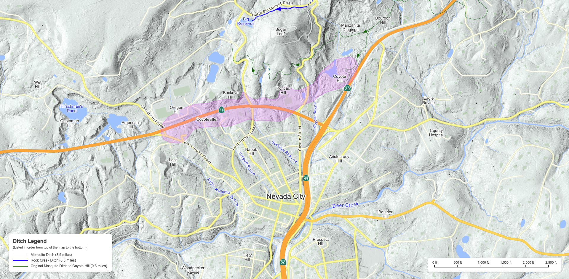
These included the 10 mining hills north of the city (going from east to west):
Bourbon Hill - Originally it was east of Manzanita Diggings, around Manzanita Diggins Drive, north of of Highway 20, although today it has moved to be on Bourbon Hill Road, east of Nevada Street. It was named for a group of bacholars that lived there.
Manzanita Hill - West of of Highway 20 and north of Nevada Street in the heart of Manzanita Diggings. Named for the ubiquitous manzanita bushes of genus Arctostaphylos.
Coyote Hill - North and west from the intersection of Highway 20 and 49, at the south end of Manzanita Diggings. Named for the round mining shafts surrounded by piles of dirt that resembled coyote burrows. Not to be confused with Coyoteville, which was between Oregon Hill and Buckeye Hill.
Pontiac Hill - Also known as Williams Hill, north of Highway 49 and west of Coyote Street, near the firestation and Tahoe National Forest HQ. Named by the Williams brothers who were from Pontiac, Michigan.
Buckeye Hill - West of North Bloomfield Road and north of Highway 49, south and east of the Madelyn Helling Library. Named for a large group of miners from the Buckeye State of Ohio.
Oregon Hill - At the top of Orchard Street, next to Maidu Avenue, around Highway 49.
Lost Hill - Between West Broad Street and Chief Kelly Drive, south of of Highway 49. Got its name as they could not find the gold-bearing ancient riverbed that should have been there. For many years, this was where the town gallows was located.
American Hill - This was west of Cement Hill Road and north of Highway 49, although today folk think of it being anywhere along American Hill Road. The original location was where hydrualic mining was first demonstrated on March 7, 1853, by 30-year-old miner and metal worker, Edward “Eddy” Matteson.
Oustomah Hill - Originally it was between Indian Flat Road and Cement Hill Road, south of Rancheria Court, but by the 1860s it had moved to where Hirschman's Pond is today. Named for the Native American Nisenan Tribe that lived just above downtown Nevada City. The original settlement at this site was called Wokodot.
Wet Hill - North of Indian Flat Road and Robinson King Road, and west of Cement Hill Road. Got its name from the constant seepage of water flooding out mine shafts there.
And then included the 5 residential hills around the city:
Boulder Hill - Up Boulder Street, to the east of The Plaza, the former town center at the bottom of Broad Street and Main Street.
Nabob Hill - at the top of Pine Street south of where it meets Broad Street. A miner's nickname for a rich person (or historical for a leader in Mogul Empire).
Aristocracy Hill - Up Nevada Street, between Washington Street and Willow Valley Road. Named for the many, wealth Southern Democrats who lived in this neighborhood in the 1850s to 1870s.
Prospect Hill (aka Rigby Hill) - Above and to the east of Sacramento Street, along Prospect Street. William Rigby was a prominent scoundrel and former felon who ran several mining scams in town.
Piety Hill - South of Deer Creek, between South Pine Street and Zion Street. An area with many fancy old houses on various streets with biblical names.
And some other close by hills near Nevada City:
Sugar Loaf Mountain - ½ mile north of Nevada City. This 3,070-foot-high landmark was named for the rounded, cone-shaped ceramic molds used to produce loaves of refined sugar. These large blocks of white sugar, weighing up to 30 pounds, were still the common way people bought sugar in the 1850s. The roadway to the top was constructed in July 1856 by a group of Frenchmen who were thinking of building a saloon at the summit.
Selby Hill - The west end of Harmony Ridge, east of Sugar Loaf Mountain. This was north south of the settlement of Selby Flat, which in 1850 was nearly as big as Nevada City itself.
Cement Hill - A mile of so north west of Nevada City, along Cement Hill. Named for the compacted volcanic ash that makes up the rock of the area.
Red Hill - 2 miles northwest of Nevada City, north of Indian Flat Road and looped by Country Circle. Named for the color of the dirt there.
Phelps Hill - 2 miles east of Nevada City, at Deer Creek Park, south of Red Dog Road, near where the D-S Canal flows by. Named for Timothy Phelps, a local miner, who went on to become a congressman and president of the Southern Pacific Railroad.
Canada Hill - 1½ miles southeast of Nevada City, east of Gracie Road and around Banner Mountain Trail.
Mouse over this map to see it in more detail or explore the interactive version.
These included the 10 mining hills north of the city (going from east to west):
And then included the 5 residential hills around the city:
And some other close by hills near Nevada City: